Water Levels
2023
Water level gauge set @ 1.20 on 5/9
Read 1/week on Tuesday
5/9 1.20
5/16 1.35
5/23 1.26
5/30 1.20
6/6 1.16
6/13 1.04
6/20 0.98
6/29 1.10
7/4 1.00
7/11 0.92
7/18 0.80
7/26 0.78
8/1 0.68
8/2 0.88
8/8 0.78
8/15 0.80
8/22 0.68
8/29 0.61
9/5 0.56
9/19 0.52
10/1 0.64
10/10 0.58
10/17 0.58
11/15 0.56
11/20 0.52 gauge removed
2022
Water level gauge set @ 1.34 on 5/20
5/20 1.32
5/31 1.46
6/5 1.38
6/16 1.29
6/28 1.35
7/8 1.28
7/25 1.26
8/4 1.13
8/13 1.06
9/3 1.04
10/2 .98
10/11 .88 removed gauge
(Each tenth of a foot is equal to a water elevation change of 1 1/5")
2021
5/16 5.16
5/23 5.10
5/30 4.96
6/6 4.90
6/13 4.80
6/20 4.67
6/27 4.70
7/4 4.60
7/11 4.60
7/18 4.50
7/25 4.44
8/1 4.32
8/8 4.26
8/15 4.14
8/22 4.16
8/29 4.22
9/12 4.10
9/19 4.06
9/26 4.10
10/3 4.20
10/10 4.30
10/24 4.16
2020
4/8 5.72
4/15 5.66
4/22 5.61
4/29 5.59
5/6 5.56
5/13 5.50
5/20 5.46
5/27 5.48
6/3 5.40
6/10 5.36
6/24 5.20
7/8 5.14
7/29 5.30
8/5 5.18
8/12 5.08
8/26 5.10
9/2 5.06
9/9 4.94
9/16 4.74 last reading
2018
level gauge set 5/31 @ 5.34
6/4 5.30
6/18 5.50
6/28 5.34
6/30 5.47
7/10 5.44
7/12 5.60
8/9 5.30
8/19 5.18
9/9 5.30
9/16 5.35
10/19 5.36 gauge removed
Secchi Disk Readings
2023
5/16 10'
6/14 13'
7/13 13'
8/16 8'
9/19 12'
2022
Secchi Readings @ 23' lake depth
5/15 13'
6/7 14'
7/13 11'
8/4 11'
9/3 10.5'
10/1 13'
2021
5/16 21.5'
6/20 19.0'
7/5 15.0'
7/14 12.0'
8/4 11.0'
9/19 11.0'
2020
4/25 13'
5/27 18'
6/4 18.5'
6/23 15.0'
7/29 12.0'
8/16 10.5'
9/5 11.0'
9/22 12.0'
2018
5/20 18.5'
6/4 16.5'
6/18 13.0'
6/28 14.0'
7/10 16.5'
8/9 12.5'
8/19 11.5'
9/16 11.0'
2015
May 4 13.5 feet
May 17 14 "
June 8 13 "
June 25 14 "
July 10 14 "
July 20 12 "
Aug 4 12.5 "
Aug 16 12.5 "
Aug 28 13 "
Sept 14 12.5 "
Sept 21 14 "
Oct 9 13.5 "
Nov 2 16.5 "
Ice Out Dates
April 30, 2023
April 29, 2022
April 1, 2021
April 8, 2020
April 21, 2019
April 29, 2018
April 3, 2017
March 26, 2016
April 7, 2015
April 25, 2014
May 9, 2013
March 22, 2012
April 17, 2011
March 31, 2010
April 18, 2009
April 29, 2022
April 1, 2021
April 8, 2020
April 21, 2019
April 29, 2018
April 3, 2017
March 26, 2016
April 7, 2015
April 25, 2014
May 9, 2013
March 22, 2012
April 17, 2011
March 31, 2010
April 18, 2009
Official Ice On Date:
November 28, 2023
Information from Minnesota DNR
Provided by Catherine McGoldrick
|
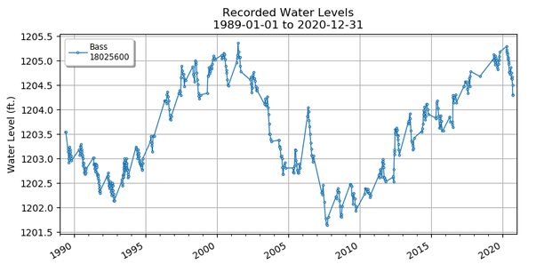
Information provided online from the DNR! Check out the fisheries report from the survey taken in June of 2016. MN DNR LakeFinder sites: The link below includes the reports and maps for our lake: http://www.dnr.state.mn.us/lakefind/lake.html?id=18025600 The following reports are available: Fisheries Lake Survey Water Accessibility Sites Water Levels Water Quality Aquatic Plant Survey The following maps are available: Water Clarity Lake Depth Recreation Compass Topographic The link below is the Lake Water Level report: http://www.dnr.state.mn.us/lakefind/showlevel.html?downum=18025600 The Lake Water Level report page contains information from reported data, including: reported historical and current lake levels period of record and number of readings highest recorded lake level highest known lake level lowest recorded lake level recorded range ordinary high water level [also shown as the red line on the 10- year graph] - click on it for definition datum benchmarks most recent 10-year graph |
Check out the water clarity data on the MPCA website. Click on the link: webapp.pca.state.mn.us/surface-water/search lake name: bass site or lake id: 18-0256-00-201 watershed: mississippi - brainerd county: crow wing Any questions? Contact Catherine McGoldrick |